Parra, Nerul and Siolim: A Village-Level Map of Goa

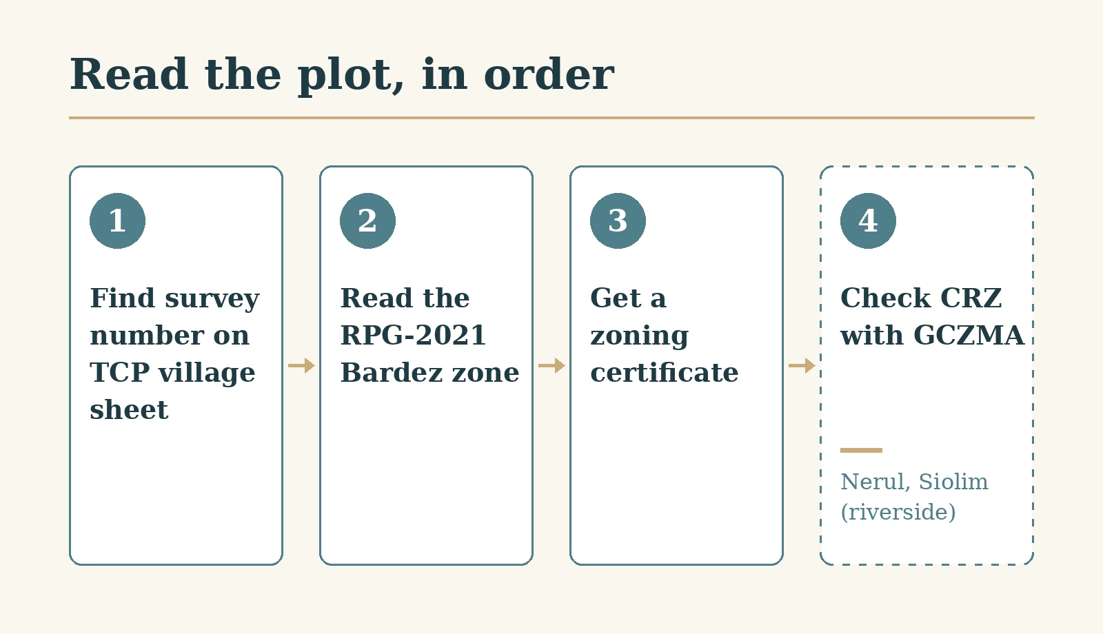
Parra, Nerul and Siolim sit in the same taluka, Bardez, and under the same statutory plan, but a buyer in each faces a different first question. In Parra the question is zoning: is the plot actually marked for settlement on the village land-use map? In Nerul, along the Nerul river towards Candolim, and in Siolim, along the Chapora, there is a second map to read as well: the coastal one. The first check is identical in all three, and it is the one most often skipped: find the plot's survey number on the official village land-use sheet. This guide explains where that sheet comes from, how to read it, what changes village by village, and what our own listings in these places do and do not tell you. It does not re-argue the case for buying early in emerging North Goa villages, which our guide to emerging areas in North Goa covers.
The map that governs all three
The plan that applies to all three places is the Revised Regional Plan for Goa 2021 (RPG-2021). Its Bardez part, together with Tiswadi, Mormugao and Salcete, was notified by the Chief Town Planner under section 15 read with section 17 of the Goa, Daman and Diu Town and Country Planning Act, 1974, by a notification dated 12 October 2011 and published in the Official Gazette on 20 October 2011 (Town and Country Planning (TCP) Department notification, read 26 October 2026). The Town and Country Planning Board had approved it at a meeting on 21 September 2011. In our paraphrase of the notification, from publication any development in the plan area has to conform to the plan, and no one may develop land in contravention of it.
The plan's report adds a point that matters for anyone reading older documents. Once RPG-2021 is in force, the older Outline Development Plans (ODPs) and zoning plans outside the five Planning and Development Authority areas (Panjim, Mapusa, Vasco, Margao and Ponda) cease to exist, and the regional plan becomes the single plan (same notification, read 26 October 2026). Whether any part of a particular village falls inside one of those five authority areas is something to confirm for the specific plot with the planning office, not something to assume from a village name.
The plan is not frozen. Zone changes are notified for public objections. For example, a gazette of 15 July 2021 notified a set of change-of-zone requests with a two-month window for objections, after a Board meeting on 28 April 2021 (TCP gazette, read 26 October 2026). Our emerging areas guide links to the current rules on zone changes under section 39A, and our guide to agricultural to non-agricultural (NA) conversion covers conversion. We do not restate either here.
How to read your plot on the village sheet
The TCP Department's land-use page for Bardez publishes separate RPG-2021 land-use maps by village panchayat, including sheets for Nerul, Parra, Siolim-Marna and Siolim-Sodiem (TCP Land Use Bardez page, read 26 October 2026). The method is the same for each:
- Download the sheet for the right panchayat. In Siolim that means first working out which of the two panchayats the plot is in.
- Find the survey number from the seller's records and match it on the sheet.
- Note the zone colour shown for that survey number, and compare it with what the seller has told you.
- Ask for a zoning certificate for the survey number from the planning authority. The sheet is a guide, and the certificate is the document a lender, a lawyer or a later buyer will ask for.
The sheets are large image files and can be hard to read at small scale, which is another reason the certificate matters. Do not rely on a screenshot sent by an agent: download the sheet yourself.
Parra: the zoning question first
Parra lies inland, away from the coast, so zoning is the first question. Before you look at title or price, find out whether the plot's survey number sits in a settlement zone on the Parra sheet, or in a zone where building is restricted. We have not read the zone mix of the Parra sheet ourselves, so we make no claim about how much of the village falls in any zone. That is precisely the check to make for your own plot.
If you are told that a plot falls under a Planning and Development Authority plan rather than the regional plan, ask for the document that shows it, and confirm with the planning office. Our Parra guide describes the village, and our North Goa guide covers the wider area.
Nerul: two maps, not one
Nerul runs along the Nerul river and towards the Candolim side of the coast. For a plot near the river, the mangroves or the shore, the land-use sheet is only half the picture. The other half is the Coastal Regulation Zone (CRZ) map.
The rules on which coastal map applies come from the CRZ Notification 2019. In our paraphrase of paragraphs 6(i) and 7(i), the 2019 provisions apply only once a state's Coastal Zone Management Plan (CZMP) has been revised under them; until then, the CZMP prepared under the 2011 notification continues to be used for appraisal and clearance, and any permitted or regulated activity needs CRZ clearance before it starts (CRZ Notification 2019, G.S.R. 37(E) of 18 January 2019, issued by the Ministry of Environment, Forest and Climate Change (MoEFCC), in the Tamil Nadu State Coastal Zone Management Authority's copy, read 26 October 2026).
We do not say which coastal plan is currently in force in Goa, or which parts of Nerul fall in any CRZ category. Both are checks to make with the Goa Coastal Zone Management Authority (GCZMA) for the specific survey number: which CZMP map the plot is read against, and what category it falls in. Our Nerul guide describes the village itself.
Siolim: two panchayat sheets
Siolim has two land-use sheets, not one: Siolim-Marna and Siolim-Sodiem. The first step is to establish which panchayat a plot is in, from its survey records, and then read the right sheet. A plot described simply as "in Siolim" could be on either.
Siolim also runs along the Chapora, so for riverside plots the coastal question in the Nerul section applies here too. As with Nerul, we make no claim about which stretches fall in which CRZ category: check with GCZMA for the survey number. Our Siolim guide describes the village, and our Morjim guide, across the river, covers a neighbouring stretch of the coast. Infrastructure plans for the area are covered separately in our piece on North Goa infrastructure.
Approvals and title: the same job everywhere
The approvals that differ by village are the zoning certificate (everywhere) and CRZ clearance where the plot falls under the coastal map (for riverside or coastal plots in Nerul and Siolim). Any conversion is a separate process; our NA conversion guide covers it, with the section 32 sanad described there rather than restated here.
Title is the same job in all three. Read the Form I and XIV, the land record extract, and trace the chain of ownership; our guides to Goa's Form I and XIV and the Goa title search explain both. For buyers abroad, our NRI land documentation checklist covers the paperwork for Non-Resident Indians (NRIs), and our list of questions before signing a land deal applies here as anywhere. Our wider guide to owning property in coastal Goa gives the broader context.
For a project registered with the Real Estate Regulatory Authority (RERA), look the project up yourself on the Goa RERA website. Do not rely on a number shown in a listing or brochure: check it on the Goa RERA register, and check that the project name and promoter match.
What our listings in these villages show
Our inventory in these three places includes villas in Parra and villas and apartments in Siolim and Nerul. Several listings in these villages show a price; here are four examples, in rupees:
- Casa Altinho, Nerul: ₹9.5 crore, as listed on avacasa.life, 26 October 2026
- Rumah Desa, Siolim: ₹5.5 crore, as listed on avacasa.life, 26 October 2026
- Villaggio Felicita, Nerul: ₹1.25 crore, as listed on avacasa.life, 26 October 2026
- La Wisteria, Siolim: ₹69 lakh, as listed on avacasa.life, 26 October 2026
Four examples, for different property types, do not make a market average, so we do not give one. They show the spread: the highest is about 13.8 times the lowest (9,50,00,000 / 69,00,000 = 13.77). None of the listings tells you a plot's zone, its CRZ position or its title history. For those, use the checks above.
Who this is not for
This is not for a buyer looking for a ranking of villages, a price trend or a rental outlook: we give none. It is not a substitute for a zoning certificate, a GCZMA check or a lawyer's title search on a specific survey number. It does not cover South Goa or other Bardez villages, and it does not cover infrastructure.
Where that leaves you
In all three villages, start with the survey number on the official village sheet, and confirm it with a zoning certificate. In Parra, that check is usually the main one. In Nerul and Siolim, add the coastal map for any plot near the river or shore, and in Siolim, first establish which of the two panchayat sheets applies. Then do the title work, which is the same everywhere. A listing can tell you what is for sale. The maps and the records tell you what you are actually buying.
Sources
- TCP Goa: notification of the Revised Regional Plan for Goa 2021, Bardez, Tiswadi, Mormugao and Salcete
- TCP Goa: Official Gazette Series III No. 16, 15 July 2021
- TCP Goa: Land Use Bardez, village land-use maps
- Tamil Nadu State Coastal Zone Management Authority: copy of CRZ Notification 2019, G.S.R. 37(E), 18 January 2019
- Ministry of Environment, Forest and Climate Change: listing of CRZ notifications
- Goa Real Estate Regulatory Authority
Ready to find your next holiday home?
Browse our curated collection of vacation homes and managed farmland across India and beyond.